Leipzig, Petersstraße 28 (Q482980): Difference between revisions
Jump to navigation
Jump to search


Georg Fertig (talk | contribs) (Created claim: Coordinate location (P48): 51°20'13.726"N, 12°22'31.022"E, #quickstatements; #temporary_batch_1683639332044) |
(Added reference to claim: Wikimedia Commons archival document reproductions (P1089): StadtAL 0008 Nr 3173 Seite 521.jpg, #quickstatements; #temporary_batch_1713170634875) |
||||||||||||||
| (56 intermediate revisions by the same user not shown) | |||||||||||||||
| Property / Address [literal] | |||||||||||||||
| Property / Address [literal]: Brandkataster alt 55 / rank | |||||||||||||||
| Property / Address [literal] | |||||||||||||||
| Property / Address [literal]: Brandkataster neu 742 / rank | |||||||||||||||
| Property / Coordinate location | |||||||||||||||
| |||||||||||||||
| Property / Coordinate location: 51°20'13.726"N, 12°22'31.022"E / rank | |||||||||||||||
| Property / Wikimedia Commons Item image | |||||||||||||||
| Property / Wikimedia Commons Item image: Lzg. 1910 Petersstraße 39-41.jpg / rank | |||||||||||||||
Normal rank | |||||||||||||||
| Property / Address [literal] | |||||||||||||||
Brandkataster neu 742 | |||||||||||||||
| Property / Address [literal]: Brandkataster neu 742 / rank | |||||||||||||||
Normal rank | |||||||||||||||
| Property / Address [literal]: Brandkataster neu 742 / qualifier | |||||||||||||||
Begin date: 1842
| |||||||||||||||
| Property / Address [literal]: Brandkataster neu 742 / reference | |||||||||||||||
| Property / Address [literal] | |||||||||||||||
Brandkataster alt 55 | |||||||||||||||
| Property / Address [literal]: Brandkataster alt 55 / rank | |||||||||||||||
Normal rank | |||||||||||||||
| Property / Address [literal]: Brandkataster alt 55 / qualifier | |||||||||||||||
End date: 1842
| |||||||||||||||
| Property / Address [literal]: Brandkataster alt 55 / reference | |||||||||||||||
| Property / Coordinate location | |||||||||||||||
51°20'14.345"N, 12°22'30.389"E
| |||||||||||||||
| Property / Coordinate location: 51°20'14.345"N, 12°22'30.389"E / rank | |||||||||||||||
Normal rank | |||||||||||||||
| Property / Coordinate location: 51°20'14.345"N, 12°22'30.389"E / reference | |||||||||||||||
| Property / Wikimedia Commons archival document reproductions | |||||||||||||||
| Property / Wikimedia Commons archival document reproductions: StadtAL 0008 Nr 3171 Seite 012.jpg / rank | |||||||||||||||
Normal rank | |||||||||||||||
| Property / Wikimedia Commons archival document reproductions: StadtAL 0008 Nr 3171 Seite 012.jpg / qualifier | |||||||||||||||
Begin date: 1807
| |||||||||||||||
| Property / Wikimedia Commons archival document reproductions: StadtAL 0008 Nr 3171 Seite 012.jpg / qualifier | |||||||||||||||
End date: 1808
| |||||||||||||||
| Property / Wikimedia Commons archival document reproductions: StadtAL 0008 Nr 3171 Seite 012.jpg / qualifier | |||||||||||||||
Address [literal]: Brandkataster alt | |||||||||||||||
| Property / Wikimedia Commons archival document reproductions: StadtAL 0008 Nr 3171 Seite 012.jpg / reference | |||||||||||||||
| Property / Wikimedia Commons archival document reproductions | |||||||||||||||
| Property / Wikimedia Commons archival document reproductions: StadtAL 0008 Nr 3172 Seite 014.jpg / rank | |||||||||||||||
Normal rank | |||||||||||||||
| Property / Wikimedia Commons archival document reproductions: StadtAL 0008 Nr 3172 Seite 014.jpg / qualifier | |||||||||||||||
Address [literal]: Brandkataster alt | |||||||||||||||
| Property / Wikimedia Commons archival document reproductions: StadtAL 0008 Nr 3172 Seite 014.jpg / qualifier | |||||||||||||||
Begin date: 1808
| |||||||||||||||
| Property / Wikimedia Commons archival document reproductions: StadtAL 0008 Nr 3172 Seite 014.jpg / qualifier | |||||||||||||||
End date: 1810
| |||||||||||||||
| Property / Wikimedia Commons archival document reproductions: StadtAL 0008 Nr 3172 Seite 014.jpg / reference | |||||||||||||||
| Property / Wikimedia Commons archival document reproductions | |||||||||||||||
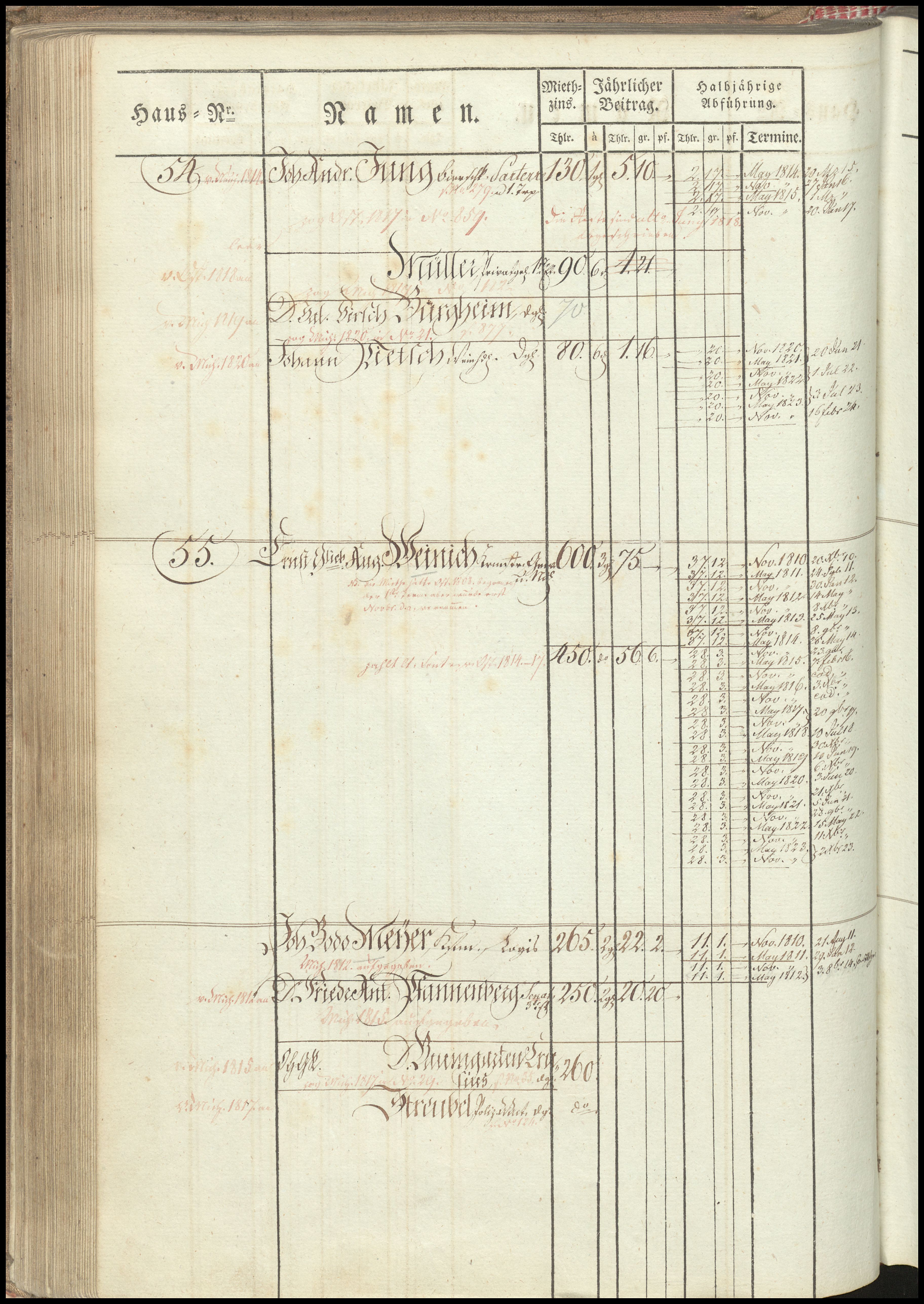
| Property / Wikimedia Commons archival document reproductions: StadtAL 0008 Nr 3173 Seite 117.jpg / rank | |||||||||||||||
Normal rank | |||||||||||||||
| Property / Wikimedia Commons archival document reproductions: StadtAL 0008 Nr 3173 Seite 117.jpg / qualifier | |||||||||||||||
Address [literal]: Brandkataster alt | |||||||||||||||
| Property / Wikimedia Commons archival document reproductions: StadtAL 0008 Nr 3173 Seite 117.jpg / qualifier | |||||||||||||||
Begin date: 1810
| |||||||||||||||
| Property / Wikimedia Commons archival document reproductions: StadtAL 0008 Nr 3173 Seite 117.jpg / qualifier | |||||||||||||||
End date: 1823
| |||||||||||||||
| Property / Wikimedia Commons archival document reproductions: StadtAL 0008 Nr 3173 Seite 117.jpg / reference | |||||||||||||||
| Property / Wikimedia Commons archival document reproductions | |||||||||||||||
| Property / Wikimedia Commons archival document reproductions: StadtAL 0008 Nr 3173 Seite 118.jpg / rank | |||||||||||||||
Normal rank | |||||||||||||||
| Property / Wikimedia Commons archival document reproductions: StadtAL 0008 Nr 3173 Seite 118.jpg / qualifier | |||||||||||||||
Address [literal]: Brandkataster alt | |||||||||||||||
| Property / Wikimedia Commons archival document reproductions: StadtAL 0008 Nr 3173 Seite 118.jpg / qualifier | |||||||||||||||
Begin date: 1810
| |||||||||||||||
| Property / Wikimedia Commons archival document reproductions: StadtAL 0008 Nr 3173 Seite 118.jpg / qualifier | |||||||||||||||
End date: 1823
| |||||||||||||||
| Property / Wikimedia Commons archival document reproductions: StadtAL 0008 Nr 3173 Seite 118.jpg / reference | |||||||||||||||
| Property / Wikimedia Commons archival document reproductions | |||||||||||||||
| Property / Wikimedia Commons archival document reproductions: StadtAL 0008 Nr 3173 Seite 119.jpg / rank | |||||||||||||||
Normal rank | |||||||||||||||
| Property / Wikimedia Commons archival document reproductions: StadtAL 0008 Nr 3173 Seite 119.jpg / qualifier | |||||||||||||||
Address [literal]: Brandkataster alt | |||||||||||||||
| Property / Wikimedia Commons archival document reproductions: StadtAL 0008 Nr 3173 Seite 119.jpg / qualifier | |||||||||||||||
Begin date: 1810
| |||||||||||||||
| Property / Wikimedia Commons archival document reproductions: StadtAL 0008 Nr 3173 Seite 119.jpg / qualifier | |||||||||||||||
End date: 1823
| |||||||||||||||
| Property / Wikimedia Commons archival document reproductions: StadtAL 0008 Nr 3173 Seite 119.jpg / reference | |||||||||||||||
| Property / Wikimedia Commons archival document reproductions | |||||||||||||||
| Property / Wikimedia Commons archival document reproductions: StadtAL 0008 Nr 3173 Seite 521.jpg / rank | |||||||||||||||
Normal rank | |||||||||||||||
| Property / Wikimedia Commons archival document reproductions: StadtAL 0008 Nr 3173 Seite 521.jpg / qualifier | |||||||||||||||
Address [literal]: Brandkataster alt | |||||||||||||||
| Property / Wikimedia Commons archival document reproductions: StadtAL 0008 Nr 3173 Seite 521.jpg / qualifier | |||||||||||||||
Begin date: 1810
| |||||||||||||||
| Property / Wikimedia Commons archival document reproductions: StadtAL 0008 Nr 3173 Seite 521.jpg / qualifier | |||||||||||||||
End date: 1823
| |||||||||||||||
| Property / Wikimedia Commons archival document reproductions: StadtAL 0008 Nr 3173 Seite 521.jpg / reference | |||||||||||||||
Latest revision as of 11:45, 15 April 2024
No description defined
| Language | Label | Description | Also known as |
|---|---|---|---|
| English | Leipzig, Petersstraße 28 |
No description defined |
Statements

Brandkataster neu 742
1842
Brandkataster alt 55
1842
51°20'14.345"N, 12°22'30.389"E

StadtAL 0008 Nr 3171 Seite 012.jpg
5,093 × 4,102; 3.81 MB
5,093 × 4,102; 3.81 MB


StadtAL 0008 Nr 3173 Seite 117.jpg
3,648 × 5,147; 3.09 MB
3,648 × 5,147; 3.09 MB

StadtAL 0008 Nr 3173 Seite 118.jpg
3,650 × 5,185; 3.44 MB
3,650 × 5,185; 3.44 MB

StadtAL 0008 Nr 3173 Seite 119.jpg
3,648 × 5,148; 3 MB
3,648 × 5,148; 3 MB

StadtAL 0008 Nr 3173 Seite 521.jpg
3,577 × 5,196; 2.81 MB
3,577 × 5,196; 2.81 MB